Map of Women Patrons’ Structures in Ottoman Istanbul | Osmanlı İstanbul’unda Kadın Bani Yapıları
SALT
Information Design, Print Design, Exhibition Design
2017
Information Design, Print Design, Exhibition Design
2017
“Produced as part for Commissioners’ Exhibition, Map of Women Patrons’ Structures in Ottoman Istanbul brings together four and a half centuries of various structures built by women, who generally belonged to the ruling or religious elite, wielding economic and sometimes even political power. Often fruits of philanthropy, these structures have survived to this day or their former locations are known. The map is derived from insurance, fire, and road maps, as well as street guides from the late Imperial and early Republican periods besides sources focusing on Ottoman women’s patronage. It is based on aerial photographs taken between 1913 and 1946, and the shoreline compiled from maps of this period in addition to the urban texture of 1927. Thus, it aims to embody a geographic and urban scenario closest to the transitional period.”
http://saltonline.org/en/map
http://saltonline.org/en/map
“İşveren Sergisi için hazırlanan Osmanlı İstanbul’unda Kadın Bani Yapıları Haritası, genellikle hanedana, yönetici elite ya da ulema hanelerine mensup; ekonomik ve yer yer siyasi iktidara sahip kadınlarca dört buçuk asır içerisinde inşa ettirilmiş çeşitli yapıları bir araya getirir. Haritada, çoğu hayır hasenat niteliğinde olan bu yapılardan bugüne ulaşanlar ile artık var olmasa da konumu bilinenler yer alır. İçerik, Osmanlı’da kadın baniliğine ilişkin kaynakların yanı sıra, geç İmparatorluk ve erken Cumhuriyet dönemlerinden sigorta, yangın, istikamet haritaları ve sokak rehberleri temelinde hazırlanmıştır. 1913-1946 aralığından hava fotoğrafları ve haritalardan derlenen kıyı çizgisi ile 1927 yılı sokak dokusu esas alınarak geçiş sürecine en yakın coğrafi ve kentsel kurgu temsil edilir.”
http://saltonline.org/tr/harita
http://saltonline.org/tr/harita

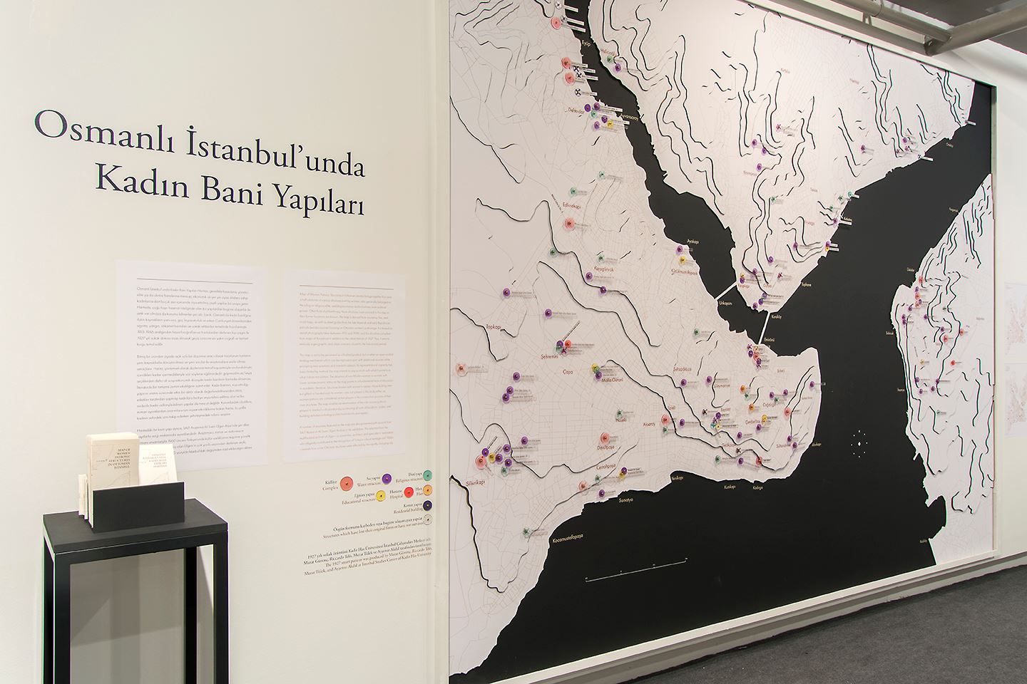
Photo Credits: Mustafa Hazneci